

Somewhere in the vast blue emptiness between Tahiti and Hawaiʻi — a stretch of open Pacific nearly 4,000 kilometers wide, with no landmarks, no GPS, no magnetic compass — a Polynesian navigator sat in the hull of a double-hulled voyaging canoe and read the sky the way a scholar reads a manuscript. He knew which stars rose over which islands. He felt the ocean swell against his hull and recognized, from its direction and rhythm, the invisible presence of land. He watched the flight paths of the golden plover and the frigatebird. He was, by any honest measure, one of the most sophisticated applied astronomers in human history.
That history has been systematically undercounted. When Western historians compiled their canons of astronomical achievement, they reached for Ptolemy, Copernicus, Galileo. Polynesian navigation — a tradition that settled islands across the central and eastern Pacific, from New Zealand to Rapa Nui (Easter Island) to Hawaiʻi, over many centuries, with New Zealand generally settled around 1250–1300 CE — was filed under “primitive seamanship” or romanticized as lucky drift voyaging. Thor Heyerdahl’s Kon-Tiki expedition (1947), which proposed that Polynesians originated in South America and drifted westward on currents, became a popular myth that actual evidence has thoroughly dismantled. The Polynesian expansion often moved eastward against the dominant trade-wind and current patterns, while also likely exploiting seasonal westerlies and variable wind regimes — which means it required intentional, skilled navigation rather than passive drifting. That is not drift. That is mastery.
The Star Compass: A Sky Divided into Bearings
The intellectual foundation of Polynesian wayfinding is the star compass (ka lā hōkū in Hawaiian, te kaveinga in Carolinian), a mental framework that divides the horizon into named directional houses corresponding to the rising and setting points of specific stars. This is not a physical instrument — it exists entirely in the navigator’s trained memory — but it functions with the precision of a protractor.
The Carolinian navigator Mau Piailug, perhaps the last master of the traditional art in the twentieth century, organized his star compass into thirty-two houses around the full horizon. Each house was anchored by a star or constellation whose rising or setting point defined a bearing. Polaris (Maan in Carolinian) marked true north. The Southern Cross (Maireng) marked south. Between them, navigators tracked Arcturus (Hōkūleʻa in Hawaiian — literally “Star of Gladness”), Antares, the Pleiades, Sirius, Aldebaran, Spica, Vega, and dozens more, each assigned to a specific house and memorized as a navigational landmark in the sky.
What makes this system astronomically sophisticated is its accommodation of stellar motion. Stars rise and set at fixed azimuths relative to the horizon — a fact that depends on the star’s declination and the observer’s latitude. A navigator sailing from the Marquesas toward Hawaiʻi, moving northward through roughly 15 degrees of latitude, must mentally adjust which stars are visible and at what angles. Mau Piailug could track this shift intuitively, recalibrating his mental compass as the voyage progressed. He carried in his head what a modern astronomer would express as a table of stellar declinations and horizon azimuths — not as numbers, but as embodied, navigable knowledge.
Zenith Stars: The Most Elegant Navigational Concept in History
Perhaps the most elegant concept in Polynesian astronomy is the zenith star — the star that passes directly overhead at a given island’s latitude. Because a star’s zenith passage is uniquely determined by latitude, a navigator who knows his destination’s zenith star can confirm his latitude simply by watching for that star to pass overhead.
Hawaiʻi, at roughly 20°N latitude, sits beneath Arcturus. The Tahitian navigators who first sailed north to discover Hawaiʻi used Arcturus as their zenith guide — a fact preserved in the Hawaiian name Hōkūleʻa, which became the name of the Hawaiian Voyaging Society’s reconstruction canoe launched in 1975. When Hōkūleʻa made its first voyage from Maui to Tahiti in 1976, guided entirely by Mau Piailug without instruments, it demonstrated empirically what scholars had debated theoretically: traditional Polynesian navigation was not myth or luck. It was a working astronomical science.
The Tuamotu Archipelago, at about 17°S, is guided by Sirius. The Society Islands, including Tahiti at about 17–18°S, also lie much closer to Sirius than to Spica, whose declination is about 11°S. Navigator training involved learning these stellar anchors for every significant island group in the Pacific — a mental atlas of the sky mapped onto geography.
Sidereal Compasses and the Etak Concept
Carolinian and Micronesian navigators developed a complementary conceptual tool called etak — a framework for tracking position during a voyage that inverts the conventional Western notion of motion. In the etak system, the canoe is conceived as stationary; it is the islands and the stars that move. A reference island (often one that is not the destination) is imagined to “move” backward along the star compass as the voyage progresses, providing a continuous positional fix.
This is not a naive confusion about physics. It is a deliberate cognitive strategy for managing dead reckoning — tracking distance traveled, current drift, and leeway — in a system where the navigator has no fixed external reference point. Modern cognitive scientists who have studied etak, including Edwin Hutchins in his landmark work Cognition in the Wild (1995), have noted that it distributes the computational load of navigation across memory, perception, and environmental cues in ways that are genuinely more efficient than Western dead-reckoning methods for the conditions involved.
The star compass and etak together constitute what we might call a dynamic sidereal reference frame — a system for tracking position relative to stellar rising and setting points while accounting for the observer’s motion through space. It is conceptually analogous to the coordinate transformations that modern astronomers perform when converting between celestial reference frames, except that Carolinian navigators performed it in their heads, continuously, over voyages lasting weeks.
Reading the Ocean as an Astronomical Instrument
Polynesian navigators did not rely on stars alone. They integrated stellar observation with a suite of environmental signals that collectively functioned as a multi-channel navigational instrument. The deep ocean swell — generated by distant storms and propagating across the Pacific in long, regular trains — provided a constant directional reference that remained readable even under cloudy skies. Mau Piailug described feeling the swell through his body, particularly through the hull of the canoe and through his testicles, which he said were especially sensitive to the subtle rolling motion of different swell directions.
Wind patterns, cloud formations over islands (land masses generate distinctive lenticular clouds visible from 50 to 100 kilometers away), the color and temperature of the water, phosphorescent wake patterns, and the flight paths of specific seabirds — all of these were read as navigational data. The golden plover (kōlea in Hawaiian) migrates annually between Hawaiʻi and Alaska, flying in flocks whose direction of travel indicated north. The frigatebird, which cannot land on water, can range far from shore but returns to land to roost, so its presence and flight patterns could be useful indicators of the direction or proximity of land.
This integration of astronomical, oceanographic, biological, and meteorological observation into a unified navigational system represents a form of what modern scientists call sensor fusion — combining multiple independent data streams to produce a more robust positional estimate than any single stream could provide. The navigators of the Pacific built this system empirically, over generations, without instruments, and encoded it in oral traditions, chants, and apprenticeship training.
The Navigational Chants: Astronomical Texts in Oral Form
The knowledge systems of Polynesian astronomy were not written in codices or carved on observatory walls. They were encoded in chant. Hawaiian navigational chants (mele hōkū, star chants) preserved the names, rising points, and seasonal appearances of navigational stars in metered verse designed for exact memorization. The Kumulipo, the Hawaiian creation chant recorded in the late eighteenth century, contains astronomical references that scholars including Rubellite Kawena Johnson have interpreted as encoding the precessional cycle — the 26,000-year wobble of Earth’s rotational axis that gradually shifts the positions of the stars relative to the seasons.
Johnson’s analysis, published in Kumulipo: The Hawaiian Hymn of Creation (1981), suggests that the chant’s structure encodes the heliacal rising of the Pleiades, which Hawaiian tradition used to mark the beginning of the new year (Makahiki season). The Pleiades’ heliacal rising shifts over centuries due to precession, and Johnson argued that the chant’s internal chronology preserves a record of this shift spanning thousands of years. Whether or not every detail of her interpretation holds, the broader point is secure: Polynesian oral traditions were not simply stories. They were data repositories, encoding astronomical observations across generations with the fidelity that other cultures achieved through written records.
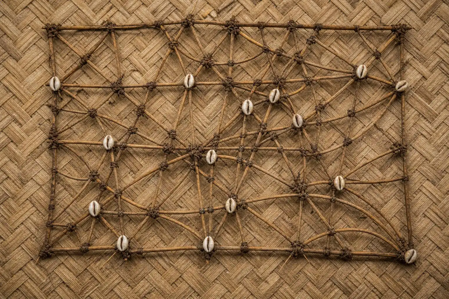
In the Marshall Islands, navigational knowledge was encoded in rebbelib and mattang — stick charts woven from pandanus strips and cowrie shells that mapped ocean swell patterns and island positions. These were not used at sea (they were teaching tools and mnemonic devices) but they demonstrate the same impulse toward systematic representation of environmental data that drives the construction of an observatory or the compilation of an astronomical table.
Jaipur’s Jantar Mantar and the Universality of Precision
It is worth pausing to place Polynesian astronomy in the context of the other great non-Western astronomical traditions. At Jaipur’s Jantar Mantar, built by Maharaja Jai Singh II between 1727 and 1734, massive stone instruments — the Samrat Yantra (a sundial accurate to two seconds), the Jai Prakash Yantra (a hemispherical bowl for tracking celestial coordinates), the Ram Yantra (a cylindrical instrument for measuring altitude and azimuth) — embodied the same drive toward precision that Polynesian navigators expressed through trained perception. Ulugh Beg’s observatory at Samarkand (1420s) housed a sextant with a radius of 40 meters, producing stellar position measurements accurate to fractions of a degree. Al-Battani’s ninth-century Kitāb az-Zīj corrected Ptolemy’s measurement of the solar year. These traditions differ in their instruments and methods, but they share an identical epistemological commitment: the sky can be known systematically, and that knowledge can be preserved and transmitted.
Polynesian navigators made the same commitment. Their instruments were their bodies and their trained perceptions. Their texts were their chants. Their observatories were open canoes on the open ocean. The precision they achieved — landfall accuracy across thousands of kilometers of featureless water — was, by any operational measure, the equal of anything produced at Samarkand or Jaipur.
The Revival and What It Teaches
The near-extinction of traditional Polynesian navigation in the twentieth century — a direct consequence of colonial disruption of indigenous knowledge systems — and its revival through the work of Mau Piailug, the Polynesian Voyaging Society, and the voyages of Hōkūleʻa constitute one of the most important stories in the history of science. Hōkūleʻa has now sailed more than 140,000 kilometers, including a circumnavigation of the globe completed in 2017, guided by traditional navigation methods. The voyage was not a historical reenactment. It was a demonstration that the system works — that the astronomical knowledge encoded in Polynesian tradition is not a cultural artifact but a functional science.
What this tradition deepens in our understanding of the sky is not merely a catalog of additional star names or navigational techniques. It deepens our understanding of what astronomical knowledge is. Western astronomy has tended to define the field by its instruments — telescopes, spectrographs, interferometers — and by its written records. Polynesian navigation reveals that astronomical knowledge can be embodied, distributed across perception and memory and community practice, and still achieve extraordinary precision. It reveals that the sky can be read not only through glass and mathematics but through the felt rhythm of the ocean, the arc of a migrating bird, and the position of Arcturus overhead on a dark Pacific night.
The stars do not belong to any one civilization’s way of knowing them. They belong to everyone who has ever looked up and paid careful attention. In the Pacific, for three thousand years, people paid very careful attention indeed.



Leave a Reply